

Stakeholder Control: Avoid War, Enable Peaceful Border Changes Thru Water Lines As Objective Boundaries
Rather than artificial political boundaries, require that all boundaries fall along river/watershed boundaries.

In an earlier article, this publication highlighted the civilized norm that non-local people do not have a right to vote on whether a different location changes its political status by becoming independent or a state/province, or some other outcome. In other words, when Kosovo, Montenegro, Scotland, Quebec, and Puerto Rico vote on independence, citizens of the countries those localities vote to leave but outside of those localities do not have a right to participate in the vote.
Reprise of Self-Determination
Dictators such as Aliyev in Azerbaijan, however, demand that all Azeris should vote on whether part of Azerbaijan, the over 90% Armenian hills of Nagorno-Karabakh/Artsakh, become independent.
This principle, that non-locals have no right to vote on a locality’s political affiliation, sounds clear cut, but it actually is not so simple because how should the boundaries of a locality be defined? Water boundaries could provide the answer. Water boundaries would include of course bodies of water such as rivers, but also boundaries between watersheds, a.k.a. drainage basins, that run along high points of land like ridges.
All Boundaries Must Follow Water Features
Humanity has traditionally sometimes used such boundaries to define political units (mostly, major rivers serving as boundaries), but could do so more universally and explicitly in order to give space to political affiliations that will always change. Throughout human history, boundaries have constantly changed. The idea frozen in place by the United Nations that current political boundaries are inviolate is unworkable: Humanity has never sat still, so humanity needs a regime of international relations that gives space for boundaries to change through democratic vote.
Defining boundaries at bodies of water and watersheds provides a natural framework for humanity to agree on areas of land the people in which have a right to self-determination. Also, a previous article in this Non-Violence publication advocated giving people the right to vote to draw boundaries, not keeping that power in unelected bureaucracies. Restricting boundaries to water features provides an objective, reality-based foundation upon which to present a range of boundary decision choices regardless of whether the democratically decide those boundaries (which is ideal), or the current system of elites deciding boundaries continues.
Defining Water Features
Take a look at this simplified map of Puerto Rico showing only major rivers in blue, and also watershed boundaries in black which are in effect ridgelines along chains of mountains/hills.
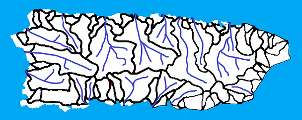
Notice a trend in watershed shape: Major rivers form watershed regions that are widest in the middle, but narrow to almost just the banks of the river as the river approaches the ocean. All areas in the mountains are part of large watersheds. Coastal areas are dominated by small watersheds, many with no major rivers worth including on this map.
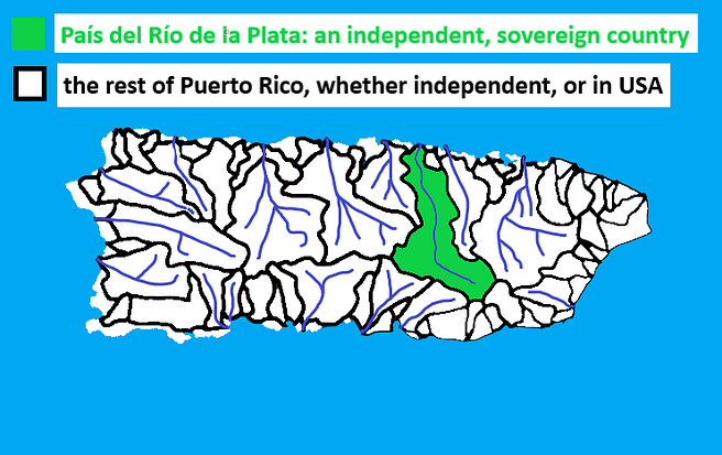
One Independent Watershed
This Non-Violence publication’s Stakeholder Control vision advocates permitting anyone in any watershed, even a stream, to declare complete independence with a supermajority vote of residents of that watershed.
Independence: Half a Watershed
